Saturday, August 6, 2011

Day 78 (8/3) Time to Find That Groove

I was determined to make up for lost time from yesterday, so I was on the right track when I woke up at 6am. That didn't last long as I climbed back into my sleeping bag for another two hours. When I finally left camp around 9, I was already miles behind where I should be. For this plan to work, I need to be doing about 22 miles a day, and I haven't gotten there yet in the first two days southbounding.

Fortunately it appears I got through the worst of the snow yesterday, and I only had a few sections to deal with through the morning. The big concern today though was water. This is a dry section (and I thought Oregon was all wet and rainy!), and I have no desire to face dehydration again. When the first creek I came to was dry, I assumed the worst about the upcoming creeks and detoured down to Middle Lake to fill up. Of course this meant being swarmed by mosquitos, so I took care of filling up as fast as possible - I probably escaped with a dozen bites. Turns out the next two creeks were flowing, but I was still glad to play it safe on this one for the sake of having enough water.

Shortly thereafter I ran into Don't Panic and Wing It, and we shared trail intel on what we had each just passed.  My next obstacle would be the snowy northern face of Devil's Peak which these two had happily just slid down. The mile of snowy ascent consumed over an hour, plus when I got cell service at the top I said goodbye to another 30 minutes. Twelve miles done by 4pm... Not good. I picked up my pace and rapidly moved past Lucifer Peak (I wonder why all the devil names for peaks?), and down Shale Butte. Somewhere in there I stopped for dinner, but wasn't hungry enough to eat more than half of it. Instead of saving it for later I opted for a walking dinner, taking a bite or two anytime I felt I could use it. I think this was a positive as it kept nge moving without cutting dinner short. At the bottom of the descent after Luther Peak I came to the perfect camp site, and gladly planted myself right there. It was only 17 miles for the day, but at least we're moving in the right direction and getting closer to that critical number.

The real cool thing to see today was a clear, close view of Mt McLaughlin, which I'll be walking past tomorrow. The north face is still snow covered and I wonder if any of that snow is a permanent glacier. Devils Peak did  have great views, and I was able to see way south to Mt Shasta, near my end point, and to the north Mt Theilsen, and Llao Rock over Crater Lake, near where I started. So from this vantage point I could see at least 350 miles of trail which blew me away a little bit. Maybe not quite the same top-of-the-world feeling I had at Mount Whitney or on Muir Pass, but pretty amazing nonetheless. Just one of the many reasons I'm having a blast out on this hike.

Miles Today: 17
Trip Mileage: 1045
PCT Mile Marker: 1800

Photo: Distant Mt. McLaughlin - my challenge for tomorrow


Wednesday, August 3, 2011

Day 77 (8/2) A-Y-C-E! (to the tune of YMCA)

So I'm not too proud of how the first half of this day went. I woke up at 6:00, but rolled over and before I knew it I was still packing up camp at 9am! We'll chalk that one up to sleeping in the last couple days while in town. Then it was only three miles to the road, where I took a slight detour to Annie's restaurant. I hadn't planned on making this stop, but when I ran into Rockdancer he happened to mention the most magical for letter acronym know to thru-hikers. AYCE: All You Can Eat. So  it turns out Annie's is a buffet style AYCE, and there is just no way I could pass that up. Its practically a rule on the trail that I had to stop. On the way in I met Sasha who started at Yosemite and plans to finish at Canada. Also there was Beacon, a veteran of the Continental Divide Trail. For some reason he decided to start with the hardest trail first and work his way back from there.

We arrived around 10:30, which was terrible timing as breakfast was over and lunch didn't start til 11:30. We weren't interested in the omelets only option during this time slot, so we waited. Finally the clock hit that wondrous time and the eating began. First, to be healthy, a plate full of salad, followed by Hawaiian pork, scalloped potatoes, chicken & rice, and pizza. All washed down with apple cobbler and two generous servings of ice cream. Had I eaten any more they would've had to roll me out of there. It was 1:30 before I finally put my pack back on, and I had still only made 3 miles. Time to book it, right?

I wish it worked that way. I doesn't the next few hours on and off snow fields, but mostly on them. This wasn't like navigating snow in the Sierras where you could see the pass miles away and just make a bee-line for it. This was Oregon forests, where the only thing you can see is trees. Route finding is a bit more  challenging, but there are a few easy guidelines to follow. (Credit to Malto for several of these) First, the trail is generally worn down below the level of the rest of the forest. This means the snow was deepest over the trail and will melt the slowest. Therefore, if you see a snow bank, that could very well be the trail. By the same token, water seeks low points, so if you see or hear a small creek running, that could very possibly be the trail. Obviously there are no trees standing on the trail, but a long time ago they discovered the answer to the question "If a tree falls in the first and nobody sees it fall, where does it land?" That ones easy - the trail. Generally crews are god about clearing downed trees - once the snow is gone. Therefore if you see a downed tree, it very possibly means the trail is right there. Finding footsteps on the snow is generally a mixed bag - sometimes it means you're right on track, if the owner of those footsteps knew where they were. But more often than not it just means you're only as far off track as the last guy, not much consolation. With all this navigational uncertainty its a shock I made as much progress as I did. I guess the big thing was to crank out miles  as fast as possible while on dry trail to make up for the slow going through the long snowy sections. 15 miles today was not sufficient, but I'm confident without the distraction of food I'll be in much better shape tomorrow.

Miles Today: 15
Trip Mileage: 1028
PCT Mile Marker: 1817

Photo: The Oregon desert - pumice soil that sucks up water leaving long stretched without access to surface water.


Day 76 (8/1) Going the Wrong Way!

This marks the official start of my 340 mile southbound PCT section from Crater Lake, OR to Dunsmuir, CA. I'm going to have ti get my head around the concept of hiking south instead of north... You would expect me to get an early start for this, but the opposite was true. First there was the continental breakfast. Then some final packing and getting out of the hotel. From there I had some chores to do at the post office. Mail out postcards, and one resupply box to Etna, then work with customer service to have my two boxes at Echo Lake forwarded one to Ashland and one to Seiad Valley. That was an easier job than expected and many thanks to Rick from the Klamath Falls PO for his help.

After all that we finally started the hour drive to Crater Lake, where I had a final lunch with my dad before he dropped me at the trail. We also picked up another hiker who was going that way - he had started at the Oregon border and was going to Canada. It was neat already meet one of the northbound hikers and I knew there would be plenty more coming. When I finally did step foot on trail it was nearly 2:00! This would clearly be only a half day at best.

The trail officially hours around the lake to keep horses away from the rim, but there is an alternate hiker trail that follows the Crater Lake rim. Obviously I took the rim trail. As I climbed the flanks of this ancient stratovolcano I wondered how it would've been before the explosion spread a good portion of this mountain across the whole west coast. It is still high enough though that this year it still held an appreciable amount of snow on August 1st. I never once imagined I would still be seeing snow at this date... Not to mention trudging through it in slushy form. Just like in the Sierras my feet got soaked. But on the other hand I got to look out on one of the most awe-inspiring places I have ever seen. For starters this lake is the deepest, purest blue you can imagine. Add to that the fact that it looks enormous, and that's before you realize its a quarter mile below you when you're standing at the rim. Then it takes on whole new proportions in your head. You might happen to notice one of the three tour boats on the lake, only they appear ant-sized and don't seem to make any progress across the lake. Only after watching for awhile do they seem to come closer to the massive Wizard Island. Reading a plaque I found out it was a 4 mile boat ride, and that's not even all the way across the lake!

Partway around I had the chance to climb the fire tower atop Watchman Peak. How could I pass that up? I had a great view of Shasta, McLaughlin, Theilsen, plus three other snow-capped behemoths in the distance, and of course the whole Crater Lake below me. What a view, and since it was snack time I spent a good while up there soaking in the sights. When I came down I didn't make it more than a mile before up the trail here comes none other than Malto.

For those few of you who haven't yet memorized every detail of my trip, I met Malto at mile 110 at Warner Springs. He started 3 days after me but caught up by doing mid-30's each day. He wanted to finish the trail in a timeline similar to mine, so we had emailed back and forth prior to the trip. I had followed his blog occasionally but was really curious how he had been doing. Apparently he was equally curious about my trip, and understood some if the challenges I had hit. He still advocated the ultra-light approach to me, and its grown on me over the course of the trip. While we caught up Redbeard came walking up, and we all talked for a bit more before we split ways to finish our miles for the day, 7 for him and 5 for me.

Miles Today: 12
Trip Mileage: 1013
PCT Mile Marker: 1832

Photo: Crater Lake panorama from adjacent to the Watchman


Day 73-75 (7/29-31) Moving the Fast Way

This morning Fool got off to a bit of a slow start leaving, but did depart by 8 or so. He has 1700 miles to go and about 75 days to do it; a 25 mile per day average. Being late will help him avoid some of the snow that slowed others down, but it is still a solid pace. I wished him the best of luck and then he was on his way. My heart sank as he left since from here on out I turn into a section hiker with no intention of finishing the trail straight thru this year... This has been obvious for weeks ever since I got injured, but skipping ahead really brings that home. I did over the first third continuous, and that section of the trip tallied over 1000 miles including the side trips I took. In a couple hours I would be speeding northward fie the final leg of my journey. What an amazing summer so far, and I hope this last section continues to exceed expectations

My dad left Sacramento around 8, do I was expecting him around 11. As I waited at the store, who showed up but Number One again! He had left a day later than us from VVR and despite our low mileage he only caught up now once I stopped. Goes to show how hard it can be to make up days on trail. We decided to grab a few beers and relax for a bit one last time before we went our separate ways. For awhile we got into a discussion with some other hikers about the PCT, which is always fun. We speculated about the status of other hiker friends of ours, and the general consensus is that many, many, many people dropped out or skipped around due to the record snow this year. It sure has put alot of people in a tough spot to finish because mid-October is about the latest you can go before hitting fresh snow in WA. Number One was unconcerned and said he would but snowshoes if that was what it took to finish the whole thing this year. Finally after an eternity my dad showed up at 12:30; he couldn't find Tuolumne Meadows and couldn't call for directions once he got into the mountains and lost service.

We grabbed burgers from the store, then went over to hang out with the other hikers whowere around. Erin and Chism were  getting ready to keep going north, and then Yoshihiro (a common PCT-L writer) was there getting ready for a trip on the JMT. He was joined by Shroomer (another PCT-L regular) and it turns out they are both my Dad's age. They all shared stories and the other two tried to convince my dad that he could do the whole thing sometime. I'm not sure I can quite imagine it, but I wouldn't be terribly shocked if he hiked some of it once (if) he retires.

After a good while we said our goodbyes and headed north, destination Echo Lake. We drove north out of the mountains and back to the 395, with clouds building to the east. As we turned up west towards Echo, the clouds seemed to close in and suddenly we were being pinged by hail. Poor rental car... As we made it further west we outran the building western edge of the storm, and made it safely to our destination. The first person I saw as I walked down to the lake was Canadoug! There were a few thrus during outside relaxing, and we spent a few minutes catching up. Turns out Steamy was a day past there and Positive ID a day back. I talked about my plan, and Canadoug cautioned that Washington was still socked in with snow and it would be slow going. He have me the idea of jumping ahead then southbounding to meet ALL the hikers still on trail. The siren had continued to build and dark clouds now threatened just to the east. We bid then farewell, got a few shots of the lakes and took off just in. to to avoid being drenched.

The second day featured plenty more driving as we worked our way up towards Crater Lake. En route I got to see Shasta and Lassen, two massive volcanos in northern California. Shasta particularly dominates the horizon, and I have to imagine seeing that everyday might inspire people to take up hiking or climbing or other outdoor sports. In Illinois we just have trees and skyscrapers, so its a wonder that anyone gets a passion for the outdoors.

We drove for hours to reach Crater Lake in the late afternoon. This wad one of the locations I had wanted to see all trip, so I wanted to make sure I would see it even if I was planning to jump ahead. This lake is something else, the largest, deepest lake I have ever seen. I marveled at the forces of nature that created this awesome place. As we drove around the park snow was still very prominent in a number of places. I could only imagine how WA would look a couple hundred miles to the north. A plan began to take shape, building off of Canadoug's suggestion. I would hike south from here and in the process run into all the remaining northbound hikers. Plus, after checking the maps I would be able to end at a town with a train station, so it would be easy to get to an airport for my flight home. Satisfied with the new plan I decided to start back on Monday the 1st and finish Wednesday the 16th in Dunsmuir, CA, 340 miles to the south.

Sunday was spent relaxing and preparing. I had to adjust my plans for resupply, sort through food, catch up on journals, upload  (a few) photos, do laundry, shower three times, and load up on calories. Also in there my dad and I managed to find time for a 5 mile hike out near Klamath Lake. He was struggling with the elevation (6,000+), and I was really enjoying walking without my pack or gear. For dinner I feasted at the Black Bear diner, a cool west coast chain. Its been a great 3 days with my Dad and I look forward to jumping back on trail tomorrow for this final leg.

Miles Today: 600 (by car)

Photo: Driving through Northern CA and OR


Monday, August 1, 2011

Day 72 (7/28) Salutations to You, Mr. Muir

Today we would finish the remaining 18 miles on the John Muir Trail. For Jeannie this would be her last hiking for awhile as she was going home to be with her boyfriend as he recovers from a series of foot injuries. We had celebrated her last day with the half liter of wine last night, and this morning a 6 point buck greeted her in camp. For once her camera worked and she was able to get a photo. I was still a little drowsy and never managed a good shot... We packed slowly, and I think despite all the hardship out here, it would be hard to cut it short at this point. I still feel like I have a lot of good hiking left in me. Within a short time though, I became quite jealous that this would be Jeannie's last day, as the mosquitos started swarming us and making life miserable. The worst was definitely Sunrise Meadow, where the trees each projected a high pitched hum, and hundreds of the pests buzzed around us biting at any opportunity. The meadow was gorgeous, but we practically ran through it to escape all 8 million of these evil guys. Actually, I think they were girls, because only the females need blood to feed their eggs. My humorous interpretation was that mosquitos are just like people, where the women all seem to be out for blood, while Jeannie said that 'at least mosquitos are the only creature where all the males aren't bugging you'. We had a good laugh over this one, while still trying our hardest to hike our way out of the swarm. Around noon I flipped on my cellphone to hear if my Dad had landed in Sacramento yet. Turns out he accidentally booked a flight for 9pm instead of 9am, so he was trying to standby on an earlier flight and would be here late tonight or tomorrow morning. Well that took all the pressure off me to finish today, but Jeannie still needed to catch teh 5:00 bus to Tuolumne and then on to Mammoth Lakes where she would start making her way back to L.A. As the day passed it was clear we would be fine to make it to the bottom by 5, but not necessarily to the bus stop, which was an indeterminate distance further from the trailhead. With about 5 miles to go Jeannie just took off, worried she might miss the bus, and I did my best to stay within sight of her. That was really tough, and the worst was when I lost her for a minute then came to a trail junction - one way was longer but was the official JMT, the other was shorter and more scenic. I figured she probably took the JMT, so guessed it would be the right way to go. I went another 20 minutes before I finally caught her resting on the side, and the whole time I was thinking she must've taken the other route.

After this she got ahead again, and coming upon a group of trail riders they let her pass but got going again before I could pass as well. I didn't expect this, but they were MUCH slower than my hiking pace, so I was forced to leisurely walk behind while chatting with a pair of hikers similarly caught. I guess the reason for the slowness was the inexperienced riders who were uncomfortable on their mounts. One was out from NY and the other came down from the Trinity Alps region of Northern California. When we could finally pass the riders we took off once more, and I was surprised that these two hikers could keep up with me easily, and in fact did much better on the downhills because they were more nimble without the big load I was carrying. At the bottom I caught up to Jeannie again, who had figured out where to go for the bus. Despite officially finishing the offical 224 miles of the JMT, there was no time for celebration as we had only 15 minutes until the bus left. The two hikers I had chatted with offered us a ride over to the bus stop, and we gladly accepted. They had been out for a week just driving around and hiking to different backwoods areas, including a couple sweet hot springs they told us about. When they dropped us at the bus stop we were loudly greeted by Fool and Joe who were waiting for the same bus as we were taking. We got to talk to them the whole way back up the hill for two hours. It was neat hearing about their hiking experiences, when they had been only a day or two ahead of us. Turns out that the tracks up the wrong pass next to Mather had been from Fool, Avocado and Muumuu, and that had been the major reason that Avocado and Muumuu decided to get off trail. They had hiked all day got to the top, realized it was wrong, turned back and hiked into the late evening by headlamp to net a total of seven miles. Wow, that sounded so much worse than the short detours that Jeannie  and I had taken... Fool would be heading north tomorrow, and Joe was also headed back to Mammoth Lakes, so at Tuolumne Fool and I got off while Jeannie and Joe continued on the bus. Neat how the pairings on trail can switch so quickly and seamlessly.

Fool and I grabbed some dinner food at the store, including my celebratory 22oz beer for finishing the John Muir Trail, then we  went over to the backpackers camp, where some nice folks let us camp at their site since we couldn't find one that was open. Tonight I wouldn't have to worry about my food since there was a bear-proof locker at the site, and everything outside my tent was crammed into that for protection from the wildlife. Tomorrow Fool would take off and I would meet up with my dad to get going on the final leg of my journey this summer.

Miles Today: (18 John Muir Trail)
Trip Mileage*: 1001^
PCT Mile Marker*: 942

*From here on out ‘Trip Mileage’ will be the total distance I have walked, and the ‘PCT Mile Marker’ will be my current location on trail. Up til now they have been the same, but that is no longer the case due to my impending jump ahead.

^Trip mileage calculated as 942 PCT miles Mexico to Tuolumne Meadows, 24 JMT miles Tuolumne Meadows to Yosemite Valley, 18 miles out and back Kearsarge Pass, 17 miles up and down Mt Whitney, smaller side trips not included in the total)

Photo: Half Dome, which sadly I didn't have time to climb


Day 71 (7/27) Two-Owl-Um?-Knee

As planned we woke up today early and quickly broke camp, leaving well before the boyscouts had a chance to get going. Thats how thru-hikers do it. We had a real easy day planned, hiking down the length of Lyell Valley to Tuolumne Meadows - a 10 mile trip. From there we would assess our situation and if we have time, hoped to continue along the JMT to finish at Happy Isles in Yosemite Valley. I decided I didn't need much food for this morning as there was a grill at Tuolumne, so that also helped with the fast start this morning. Plus, I lost my spoon a few days ago, so eating has been a bit more of a challenge without that utensil. For the messy stuff I've been forced to borrow a broken spoon from Jeannie. That McFlurry spoon lasted about 550 miles from Cajon Pass, and I'm absolutely sold on using them in the future as a lightweight and durable alternative to expensive titanium spoons.

The miles went quickly past as we followed the downward slope of the valley and river into Tuolumne Meadows. Jeannie and I took a bet about how many times we would be asked about the conditions on Donohue Pass. She guessed four, and I guessed six. There were two early on, and I felt confident that as we got closer to the trailhead the number of questions would increase. Sadly, I was wrong as the number of day hikers increased and the majority of JMT hikers had already passed in the early morning. As we made it further down it became evident that Jeannie had been dead on with her guess of four, and I had little or no chance of picking up two more, even if I did try my hardest to get random people to ask about the pass. Walking along we wished we had a small raft to glide down the water, which slid silently past us, easily outrunning our respectable 3 mph pace. The only issue with a raft would be carrying it when not on water, but man it would've been awesome today... In the last mile from the trailhead we saw a number of families out hiking together, including some kids that looked totally dejected at the idea of hiking through the woods. I bet I did that occasionally, but I did feel sorry for them that they already weren't enjoying themselves only a mile or two in. It would be a long day for them I bet. At the bottom we followed the trail, and then ended up with a mile long trek over to the store. We were both hungry and impatient, so that walk seemed to take forever. Jeannie hadn't seen the maps, so every building we passed first raised and then dashed her hopes. Finally we came to the store where I picked up a burger and ice cream, along with my pair of resupply packages. These contained the seven days of food required to get me to Echo Lake, but I would instead be using part of it for the hike down to Yosemite Valley and the rest for Washington. There was no way this all could fit in the bear canister, so I did my best to cram in the smelly stuff and then everything else went into a different stuff sack which would hopefully not be raided by animals...

At the store I ran into Avocado, who I almost didn't recognize, and then Muumuu and another friend of theirs. We chatted and caught up - turns out they are getting off trail to go biking instead, so this was their last stop. They'd hiked a bit with Joe and Fool, who were both now on their way down to Yosemite Valley and Half Dome, so maybe we would see them on our trip if we hurried. I was in no hurry though, as it felt great to sit down and relax for a little bit. Finally after about 2 hours it was time to get going again, and Jeannie and I decided to pick up a little celebratory treat for this evening since it was her last night. The store happened to sell wine in bags, so we picked up a half liter of Sangria and set off on our way, bidding goodbye to our old friends one last time. The interesting part about this section is that since it is off the PCT we didn't have maps that covered it. As a result we weren't quite sure how far it would be, though we had heard conflicting reports that it was anywhere from 18 to 28 miles. I think we settled on 24 and figured it would be easy to do it by the 5:00 bus back up to Tuolumne tomorrow. The JMT around the store was pretty well signed, so we had no worries about staying on the right trail as we went forward. Additionally, we knew that we would drop a net 4,000 feet of elevation, so the terrain couldn't be that terrible, right? Early on we did a few short climbs followed by reasonable descents, all well marked with mileages to locations ahead. We settled on stopping at Cathedral Meadows / Lake after a six mile haul. I was aching more than usual due to the extra food load, and plus we weren't too worried about the overall mileage. When we got to the meadow we stopped and made dinner, and throughout the whole meal we were swarmed by mosquitos. That made up our mind to camp away from the meadow, so we walked 0.2 miles up before setting up under some scraggly pines. Hopefully they would provide enough cover to prevent the worst of the potential condensation. I was a bit concerned about the extra food outside my bear canister, but since we were camped away from where we cooked hopefully the lack of smells at our site would prevent a bear or other critters from becoming interested in my goodies.

Miles Today: 10 (+6 JMT)
Trip Mileage: 942

Photo: Lyell Fork of the Tuolumne River

Day 70 (7/26) Who Said It’s All About Hiking Anyway?


This morning as I got up I was greeted by a new four-legged friend (my first of the day) who was out hiking with his owner. They both passed and I quickly began packing. It would be a big day, and I could potentially hit Tuolumne Meadows in Yosemite by this evening. My dad will be there on Thursday, so I figure I’ll finish the John Muir Trail in the meantime as there is a 24 mile section that splits away from the PCT to drop into Yosemite Valley. My dad will be spending a few days out here and I think the plan is to drive up to the Oregon/Washington border with him and then hike north to Canada from there. Washington is by far the most remote, so it would be the hardest section to do in pieces later. Plus, I really want to get up there to see Rainier, Hood, and some of the other spectacular mountains in the Cascades. So, that's the incentive to get moving.

Look at that form!
Despite the desire to get going quickly, I did have a short intermission planned. Because we stopped shy of Thousand Island Lake last night and I didn’t get to swim / rinse off, I decided to do that this morning. First off, lakes are generally pleasant to swim in during the late afternoon and evening because they’ve spent all day in the sun. In the morning, they’ve been cooling off for the last bunch of hours, so they are nice and frosty. Okay, so resume story. Jeanie and I come up to the lake after an hour and a half of hiking, and there sits a whole troop of boy scouts. Undeterred, I strip down to my boxers and jump in, heading for the first island. There are a few caveats to this trip - for starters I’ve barely used my arms for the last two months (lifting my pack isn’t that much work...), and I have a terrible sense of distance over water, and that island was at least 100 meters away, if not more. I jump in and start swimming. I started out well doing a great frontstroke, but quickly tired and swapped to a sidestroke. At least Jeannie snapped the shot while I was swimming hard and with good form. By the time I hit the midway point, I realized this was COLD water, and wanted to hurry up, so switched back to a strong frontstroke. The distance slowly closed, and finally I put a foot down on a slimy rock, careful not to mash a toe into the granite. I hauled myself out of the water, raised my arms over my head, and gave a triumphant whoop of victory. Jeannie snapped a second great photo, and with that I dropped to the ground to rest and warm up. That was the biggest workout for my arms in awhile, and I was also pretty well chilled. The sun took care of the second problem, while my body rapidly worked to recover after the first. After a few minutes, I got up, surveyed my island, and spotted a MUCH shorter way back to shore on a different bank. Satisfied with my accomplishment, I dunked myself back in the water and quickly made my way back to dry land and walked the rest of the way back to my clothes. Okay, so I was pretty cold, and definitely had to take in some calories to get my body working again. So worthwhile, but I think next time I go for a swim in an alpine lake, I’ll make sure its above 45F...

Success! Notice, this was zoomed in pretty far and it still looks FAR away
We probably spent at least an hour on the swimming detour, but who said this trip is all about hiking anyway? As a good friend Sourdough once put it, in his wonderful Georgia accent, “Don’t let the hiking get in the way of your experience,” and especially since my injury I’ve made sure to take that to heart. How many times do you get to swim in a perfectly blue alpine lake anyway? So, with a smile on my face we both set off towards Island Pass, which really didn’t seem to be like a challenge since the terrain was mostly level going up to it according to the map. Well, maybe it was my recent borderline hypothermia, or maybe this just happened to be a difficult section to navigate, but somehow Jeannie and I missed a turn on the PCT when it went under snow, and we spent the next hour or so wandering around looking for this “Pass” which turned out to be nothing more than a low point next to a small hill. Some pass, and it definitely didn’t stand out like most of the previous ones. As we became more frustrated, we turned once again to the GPS - this time Jeannie’s didn’t work (I think I’m gonna rename her Fritz for all the faulty electronics) so I used my phone to get a fix. We were about a half mile away over rough terrain, so it took a bit to get over to the right spot. Finally, she spotted a faint hint of trail across the way, and we scrambled up to find it. Success! And with that, we broke for lunch, once again worn down after only a relatively short number of trail miles.

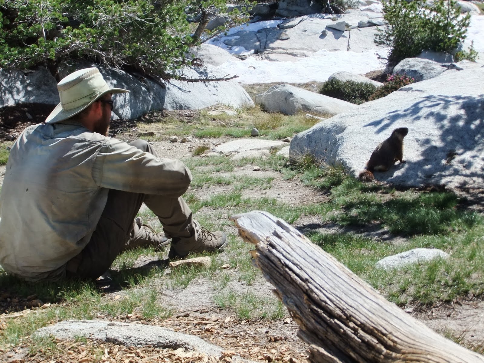
My new marmot friend. Marm't!
As we got going again the next checkpoint was Donohue Pass. This was a little bit more pass-esque, as we would climb a few thousand feet up to this one, crossing over onto snow about a mile before the summit. At one point before we got to the snow I stopped to dig a hole and take care of business, and was greeted by a friendly marmot who was interested in all the dirt I had dug up (presumably for ants or roots or seeds or something rather than what I had left). He was so bold, I was able to get within a couple feet of him by slowly progressing and waiting for him to accept that new distance. I yelled for Jeannie to come over and we each got some photos with our new four-legged friend (the second of the day). After we messed around with this guy for awhile, we finally decided it was time to head up the pass. There were several groups on their way down, and we had no problem following the “expressway” of footprints straight to the top. In a number of sections I questioned the judgement of those who had walked here before as they came quite close to the edges of rocks which can be melted out and fall beneath you. Last year a PCT hiker postholed next to a rock and tore open his leg from ankle to knee, requiring a helicopter ride out once they stopped the bleeding. I had no desire for a similar $15,000 trip, so I chose to detour around those questionable areas. I'm sure my mother is currently breathing a sigh of relief.

At the top we were treated to some sweet views of the valley ahead and behind us, including the Lyell glacier which feeds a fork of the Tuolumne River. We descended the snowfield and came to a quite unique sight - the very headwaters of the river. We stood at the base of the glacier where the water ran out from under the snow into a lake, and then slowly meandered out and down the valley, occasionally augmented by the flow from streams down the neighboring hills. We were a bit unsure of the trail location, but decided to turn back when we reached a snow covered cascade to the valley below. There were tracks traversing down, but we had no desire to mess with that. 45 minutes later we had worked our way around, following the PCT a bit more closely, but having overshot the descent trail, we found ourselves bouldering down to the base. So much for an easy route. The first creek (river) crossing was an easy ford, but it is always frustrating to soak your feet at the end of the night. We tacked on another mile down to a lower campsite, which coincidentally was shared by the same boyscouts we had seen this morning at Thousand Island Lake. We’ll have to get an early start tomorrow to make sure we aren’t shown up by these teenagers...

Miles Today: 12
Trip Mileage: 932

Headwaters of the Lyell Fork of the Tuolumne River