This morning as I got up I was greeted by a new four-legged friend (my first of the day) who was out hiking with his owner. They both passed and I quickly began packing. It would be a big day, and I could potentially hit Tuolumne Meadows in Yosemite by this evening. My dad will be there on Thursday, so I figure I’ll finish the John Muir Trail in the meantime as there is a 24 mile section that splits away from the PCT to drop into Yosemite Valley. My dad will be spending a few days out here and I think the plan is to drive up to the Oregon/Washington border with him and then hike north to Canada from there. Washington is by far the most remote, so it would be the hardest section to do in pieces later. Plus, I really want to get up there to see Rainier, Hood, and some of the other spectacular mountains in the Cascades. So, that's the incentive to get moving.
 |
| Look at that form! |
Despite the desire to get going quickly, I did have a short intermission planned. Because we stopped shy of Thousand Island Lake last night and I didn’t get to swim / rinse off, I decided to do that this morning. First off, lakes are generally pleasant to swim in during the late afternoon and evening because they’ve spent all day in the sun. In the morning, they’ve been cooling off for the last bunch of hours, so they are nice and frosty. Okay, so resume story. Jeanie and I come up to the lake after an hour and a half of hiking, and there sits a whole troop of boy scouts. Undeterred, I strip down to my boxers and jump in, heading for the first island. There are a few caveats to this trip - for starters I’ve barely used my arms for the last two months (lifting my pack isn’t that much work...), and I have a terrible sense of distance over water, and that island was at least 100 meters away, if not more. I jump in and start swimming. I started out well doing a great frontstroke, but quickly tired and swapped to a sidestroke. At least Jeannie snapped the shot while I was swimming hard and with good form. By the time I hit the midway point, I realized this was COLD water, and wanted to hurry up, so switched back to a strong frontstroke. The distance slowly closed, and finally I put a foot down on a slimy rock, careful not to mash a toe into the granite. I hauled myself out of the water, raised my arms over my head, and gave a triumphant whoop of victory. Jeannie snapped a second great photo, and with that I dropped to the ground to rest and warm up. That was the biggest workout for my arms in awhile, and I was also pretty well chilled. The sun took care of the second problem, while my body rapidly worked to recover after the first. After a few minutes, I got up, surveyed my island, and spotted a MUCH shorter way back to shore on a different bank. Satisfied with my accomplishment, I dunked myself back in the water and quickly made my way back to dry land and walked the rest of the way back to my clothes. Okay, so I was pretty cold, and definitely had to take in some calories to get my body working again. So worthwhile, but I think next time I go for a swim in an alpine lake, I’ll make sure its above 45F...
 |
| Success! Notice, this was zoomed in pretty far and it still looks FAR away |
We probably spent at least an hour on the swimming detour, but who said this trip is all about hiking anyway? As a good friend Sourdough once put it, in his wonderful Georgia accent, “Don’t let the hiking get in the way of your experience,” and especially since my injury I’ve made sure to take that to heart. How many times do you get to swim in a perfectly blue alpine lake anyway? So, with a smile on my face we both set off towards Island Pass, which really didn’t seem to be like a challenge since the terrain was mostly level going up to it according to the map. Well, maybe it was my recent borderline hypothermia, or maybe this just happened to be a difficult section to navigate, but somehow Jeannie and I missed a turn on the PCT when it went under snow, and we spent the next hour or so wandering around looking for this “Pass” which turned out to be nothing more than a low point next to a small hill. Some pass, and it definitely didn’t stand out like most of the previous ones. As we became more frustrated, we turned once again to the GPS - this time Jeannie’s didn’t work (I think I’m gonna rename her Fritz for all the faulty electronics) so I used my phone to get a fix. We were about a half mile away over rough terrain, so it took a bit to get over to the right spot. Finally, she spotted a faint hint of trail across the way, and we scrambled up to find it. Success! And with that, we broke for lunch, once again worn down after only a relatively short number of trail miles.
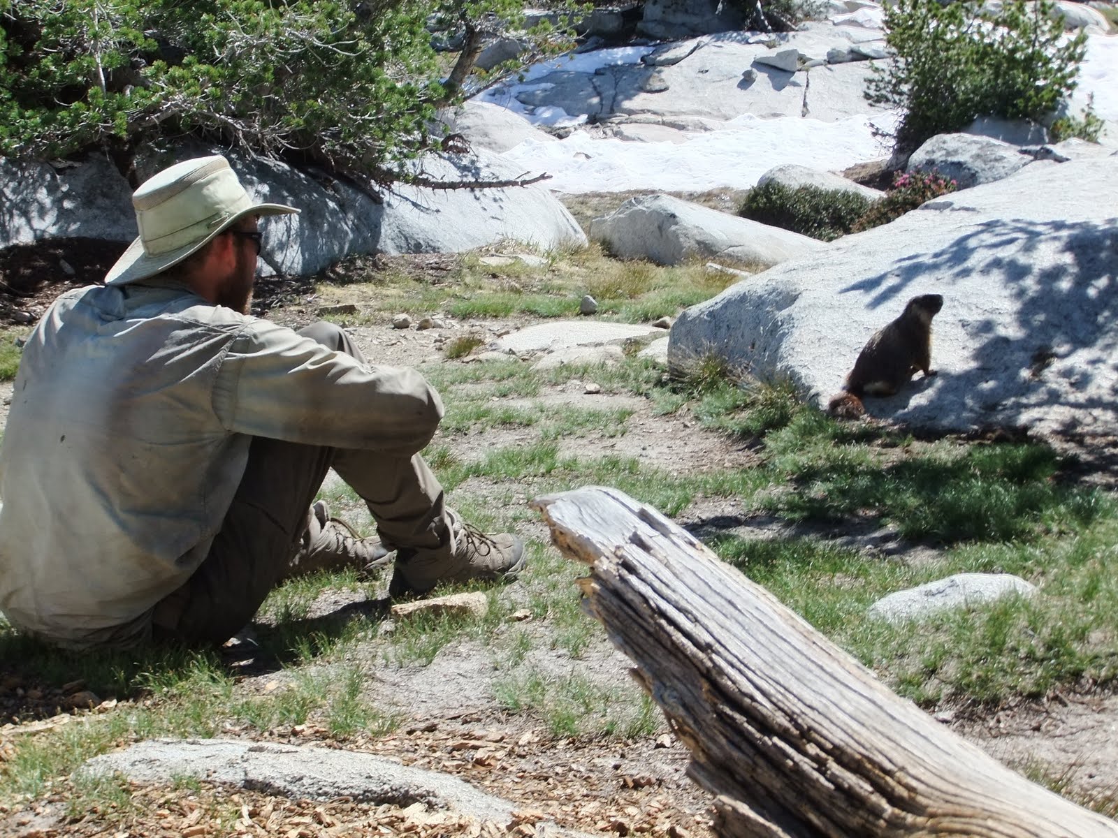
 |
| My new marmot friend. Marm't! |
As we got going again the next checkpoint was Donohue Pass. This was a little bit more pass-esque, as we would climb a few thousand feet up to this one, crossing over onto snow about a mile before the summit. At one point before we got to the snow I stopped to dig a hole and take care of business, and was greeted by a friendly marmot who was interested in all the dirt I had dug up (presumably for ants or roots or seeds or something rather than what I had left). He was so bold, I was able to get within a couple feet of him by slowly progressing and waiting for him to accept that new distance. I yelled for Jeannie to come over and we each got some photos with our new four-legged friend (the second of the day). After we messed around with this guy for awhile, we finally decided it was time to head up the pass. There were several groups on their way down, and we had no problem following the “expressway” of footprints straight to the top. In a number of sections I questioned the judgement of those who had walked here before as they came quite close to the edges of rocks which can be melted out and fall beneath you. Last year a PCT hiker postholed next to a rock and tore open his leg from ankle to knee, requiring a helicopter ride out once they stopped the bleeding. I had no desire for a similar $15,000 trip, so I chose to detour around those questionable areas. I'm sure my mother is currently breathing a sigh of relief.
At the top we were treated to some sweet views of the valley ahead and behind us, including the Lyell glacier which feeds a fork of the Tuolumne River. We descended the snowfield and came to a quite unique sight - the very headwaters of the river. We stood at the base of the glacier where the water ran out from under the snow into a lake, and then slowly meandered out and down the valley, occasionally augmented by the flow from streams down the neighboring hills. We were a bit unsure of the trail location, but decided to turn back when we reached a snow covered cascade to the valley below. There were tracks traversing down, but we had no desire to mess with that. 45 minutes later we had worked our way around, following the PCT a bit more closely, but having overshot the descent trail, we found ourselves bouldering down to the base. So much for an easy route. The first creek (river) crossing was an easy ford, but it is always frustrating to soak your feet at the end of the night. We tacked on another mile down to a lower campsite, which coincidentally was shared by the same boyscouts we had seen this morning at Thousand Island Lake. We’ll have to get an early start tomorrow to make sure we aren’t shown up by these teenagers...
Miles Today: 12
Trip Mileage: 932
 |
| Headwaters of the Lyell Fork of the Tuolumne River |


No comments:
Post a Comment